
Activities
Old Route 40 - Ellsworth County, Kansas
Old 40 Highway played a major role in the history of Ellsworth County. It is alternately called the Smoky Hill Trail, Old 40 Highway, and the Golden Belt Highway.
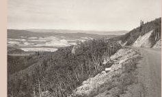 Parts of the old road are still in use today. From Ellsworth east, the road goes to
the Missouri state line, and west from Ellsworth, you can follow it to Russell County,
where it dead-ends at Interstate 70. But there are segments that are in usable
condition on westward to Fort Hays and Fort Wallace, then on to Colorado, across the
Rocky Mountains, and all the way to California.
Parts of the old road are still in use today. From Ellsworth east, the road goes to
the Missouri state line, and west from Ellsworth, you can follow it to Russell County,
where it dead-ends at Interstate 70. But there are segments that are in usable
condition on westward to Fort Hays and Fort Wallace, then on to Colorado, across the
Rocky Mountains, and all the way to California.
Members of the Smoky Hill Chapter Daughters of the American Revolution are collecting memories of Old Hiway 40 from the time of its conception in 1925 to its demise in the 1960s as an interstate highway.
These memories are about construction, businesses, or incidents connected with this important piece of history in Ellsworth and Ellsworth County.
The Beginnings
 The Smoky Hill Trail made its beginning on the banks of the river at Leavenworth. The
famed "Buffalo Soldiers" were guardians of the Trail. A distance from Leavenworth, the
Trail split and part of it turned south, and the main road continued westward along
the Kansas Pacific Railroad and the rivers.
The Smoky Hill Trail made its beginning on the banks of the river at Leavenworth. The
famed "Buffalo Soldiers" were guardians of the Trail. A distance from Leavenworth, the
Trail split and part of it turned south, and the main road continued westward along
the Kansas Pacific Railroad and the rivers.
Highway 40 was created in 1925 when the U.S. Bureau of Public Roads drew a line on a map connecting routes from the Atlantic to the Pacific. The most famous of these routes was the National Road which was birthed in 1805 and fathered by Thomas Jefferson. It stretched from Cumberland, Maryland, to the Ohio River as the first federal highway.
More about the National Road can be read in "America's Main Street: The Historic National Road," published in the DAR publication, American Spirit, in the July/Aug. 2007 issue on page 36.
Another resource for information is the Route 40 website.World War I
In Kansas, the line of Highway 40 followed the Victory Highway, which was established in 1920 as a memorial to the veterans of World War I. Victory Highway included sections of the Golden Belt Road, established in 1910. For years, the Kansas portion of Highway 40 consisted of roads constructed, supervised, and maintained by the counties.
In 1931, Kansas was the last state in the union to approve funding of its roads and highways. In 1933, the National Recovery Industrial Act allotted Kansas $10 million to spend on highway projects, employing men from the County Relief Rolls, a WPA program. Unskilled workmen were paid 30 cents an hour, semi-skilled, 40 cents, and skilled labor, 60 cents. Maintenance crews were used as field supervisors.
World War II
In 1941, the U.S. War Department designated parts of Highways 40 and 24 as indispensable to national security. Construction crews worked long hours to build access and multi-lane roads to military and defense facilities. By the end of World War II, other state and local roads were deteriorating. Within a few months, contractors were at work on $17 million worth of state projects.
Interstate Highway System Emerges
In 1956, President Eisenhower signed the Federal Aid Highway Act, providing for a multilane interstate super highway. This was the largest public works project in history and was completed in 13 years. Interstate 70, part of that project, parallels Old Highway 40, which is the Smoky Hills Trail.
--History submitted by Jean.
Tales Of Old Route 40Summer 1929I was raised on a farm down by Geneseo, Kansas. It was always known that I would go to Fort Hays State Teachers College to become a teacher. So in the summer of 1929, I began my college education. At that time, the old 40 was a gravel road and I traveled this road each summer of 1929, 1930, and 1931. It had a hard surface in 1931, but was not of concrete. In 1932, the US Government gave the states managemnet of the highways, and also they gave the financial responsibilty to each one, and Kansas inherited the Smoky Hill Trail and Golden Belt Highway and renamed it Highway 40.
When you traveled from Ellsworth to Salina, approximately 35 miles, you saw vehicles of all sizes and shapes on old 40. Mr. Bailey had a trucking business through the mid-1930s. He would drive a load of cattle to the Salina Livestock Sale Barn and return home with sacks of feed for the Co-op. He also brought back barrels of oats and sold to Mr. Toman. Mr. Bailey would thresh the hay from Wamego farmers and truck the hay back to the farmers in Ellsworth County. 
Icing Glass Hill near Carneiro was very high and rocky. They cut a road through that rock almost in line with the road that was in existance. Remember, the railroad was being built along side the old Trail Road at the same time, so there were many folks who would put up tent towns or shanty towns as living quarters. The Icing Glass Hill was a very dangerous crossing in the winter time. There was always a lot of snow and ice that made driving dangerous, so in order for vehicles to use this road, tire chains had to be on the vehicles. Sometimes the farmers would have to assist people over the hill. So the blasting of Icing Glass Hill prompted the rebuilding of a good road that would be passable in the winter. --Charlene's memories transcribed by Rose. |
 I was going to Hays to college each summer and teaching country school each winter
those four years. From year to year, I noticed changes taking place in my eighty-mile
trek across the prairie. After the road was named Highway 40, businesses began to spring
up at Ellsworth. Lockharts built a motel on the north side, Joe Toman opened a filling
station and appliance store, selling gas and oil, stoves and refrigerators. On the north
side, Ott Ullman opened a building where he bought farmers' eggs and trucked them to
Colorado. Soil Conservation opened an office there also.
I was going to Hays to college each summer and teaching country school each winter
those four years. From year to year, I noticed changes taking place in my eighty-mile
trek across the prairie. After the road was named Highway 40, businesses began to spring
up at Ellsworth. Lockharts built a motel on the north side, Joe Toman opened a filling
station and appliance store, selling gas and oil, stoves and refrigerators. On the north
side, Ott Ullman opened a building where he bought farmers' eggs and trucked them to
Colorado. Soil Conservation opened an office there also.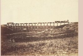 As the road was changed from gravel to hard top, the highway workers stayed at the
motel and other places. This was a very busy time for the cattle town of Ellsworth. Not
only was Old 40 being built to the north, but to the south of town, the Union Pacific
or Kansas Pacific Railroad was being built. The highway workers stayed in places on
the north and the railroad workers built their little town on the south. The Terra
Cotta Railroad station was moved into Ellsworth from Carneiro, placed beside the
Lockhart Motel, and was made into a tavern.
As the road was changed from gravel to hard top, the highway workers stayed at the
motel and other places. This was a very busy time for the cattle town of Ellsworth. Not
only was Old 40 being built to the north, but to the south of town, the Union Pacific
or Kansas Pacific Railroad was being built. The highway workers stayed in places on
the north and the railroad workers built their little town on the south. The Terra
Cotta Railroad station was moved into Ellsworth from Carneiro, placed beside the
Lockhart Motel, and was made into a tavern.Ellsworth County Kansas
January 23, 1924
ELLSWORTH COUNTY LOSES FAMOUS ROAD BUILDER
BY DEATH. HE MADE THE GOLDEN BELT GOOD.
Seppe Ulrickson died at his home here Tuesday morning. Born in Denmark 75 years ago last September, he came to this country when a young man and engaged in farming. His farming operations were not very successful and fifteen years ago he moved into Carneiro and was elected road supervisor of this township.
HE BUILT GOOD ROADS...
The county officials took notice of his work. They offered him small jobs on the Golden Belt Road and he always made good. Since then he was in charge of most of the grading of the Golden Belt Road from the Saline County line to Ellsworth... (It) is considered the road from the Saline line a monument to his memory. It is doubtful if Central Kansas had his peer as a road worker. While visiting some of his children in another state about two weeks ago, he became stricken with paralysis and was unconscious most of the time until his death. His wife, five sons and three daughters survive.
A FINE ROADBUILDER
Salina KS. Seppe Ulrickson is dead. He had the reputation of being the best road builder in Central Kansas and hundreds of tourists passing through the state on the Golden Belt Road admired his work between the west most line of Saline County and Ellsworth County. Ulrickson was born 75 years ago in Denmark and came to America when young.
The Ellsworth Messenger
November 15, 1934
ROAD ACCIDENT FATAL TO ARTHUR CAMPBELL
DECEASED, NATIVE OF ELLSWORTH COUNTY,
WAS EMPLOYED ON HIGHWAY PAVING PROJECT.
Arthur Campbell of Carneiro, age 35, was instantly killed last Saturday morning about 7:30 o'clock when struck on the head by the skip of the concrete mixer at the U.S. 40 Highway job four miles west of Ellsworth. The death was purely accidental, according to officials of Harrison Construction Company and employees who saw it. Campbell's skull was fractured from the blow.
Funeral services conducted by Rev. Albert D. Hall, Kanopolis, were held Monday afternoon at the Methodist Church in Carneiro. Burial was in the Carniero Cemetery.
Arthur Charles Campbell was born near Crawford, this state, on the Sherman Ranch, Feb. 16, 1899. When he was 12 years of age, his parents moved to near Geneseo where he lived until June 1927 when he married Eliza (Dolly) Cook of Carniero. Mr. and Mrs. Campbell made their home on the Sherman Ranch from the time of their marriage up until June of this year with the exception of one winter spent in Carneiro.
Surviving Mr. Campbell are his wife, four children, Muriel, Vernon, Lloyd and Lillian, His mother, Mrs. Marie Wynn of Lyons, two sisters, Mrs. Lena Hemry of Lyons and Mrs. Fannie Hysell of Geneseo and two brothers, Dan and George, on the Sherman Ranch.
--Obituaries submitted by Iris.
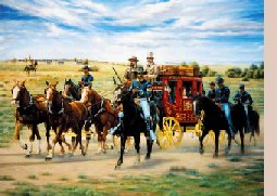
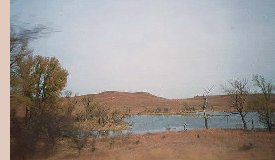
Sights of Old Route 40Fort HarkerThe original post was established in August 1864 to protect the more remote frontier settlements. It was first called Fort Ellsworth, named for 2nd Lieutenant Allen Ellsworth, commander of the 7th Iowa Cavalry, the fort's first occupants. The fort was originally located on the left bank of the Smoky Hill River at the point where the Santa Fe stage route crossed the river, about 3-4 miles southeast of the present town of Ellsworth.
The Faris Caves
|
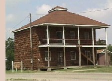 The fort was renamed Fort Harker in 1866 to honor Brigadier General Charles G. Harker, who was killed on
27 June 1864 in the Battle of Kenesaw Mountain. In January 1867, the post was moved one mile northeast to the
site of the present town of Kanopolis, in Ellsworth County. The post was used as a base for the distribution of
supplies to posts farther west and for operations against hostile Indians in 1868-1869. Later, Fort Harker served
to protect the construction crews of the Kansas Pacific Railway. The usefulness of the post ended when the
railroad reached Denver, and it was abandoned in 1873. The military reservation was transferred to the Interior
Department on 12 July 1880. Today, the guardhouse is part of the Ellsworth County Historical Society's
museum complex.
The fort was renamed Fort Harker in 1866 to honor Brigadier General Charles G. Harker, who was killed on
27 June 1864 in the Battle of Kenesaw Mountain. In January 1867, the post was moved one mile northeast to the
site of the present town of Kanopolis, in Ellsworth County. The post was used as a base for the distribution of
supplies to posts farther west and for operations against hostile Indians in 1868-1869. Later, Fort Harker served
to protect the construction crews of the Kansas Pacific Railway. The usefulness of the post ended when the
railroad reached Denver, and it was abandoned in 1873. The military reservation was transferred to the Interior
Department on 12 July 1880. Today, the guardhouse is part of the Ellsworth County Historical Society's
museum complex.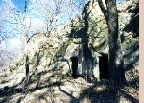 The caves called The Faris Caves were carved out of the native Dakota sandstone in the 1880s by a Colorado miner
named Charles Griffee. He lived in the caves only a short while before selling the land to the Faris family in 1893. The
Faris Ranch grew to one of the largest in the area. Though the Faris family constructed a house nearby, they used the
caves as a spring house, a generator room, and for a short time, as a school. Photo courtesy H. J.
Schuster, used with permission.
The caves called The Faris Caves were carved out of the native Dakota sandstone in the 1880s by a Colorado miner
named Charles Griffee. He lived in the caves only a short while before selling the land to the Faris family in 1893. The
Faris Ranch grew to one of the largest in the area. Though the Faris family constructed a house nearby, they used the
caves as a spring house, a generator room, and for a short time, as a school. Photo courtesy H. J.
Schuster, used with permission.